Tuesday, April 14, 2020

Top 12 MINDBLOWING Ocean Mysteries And Phenomena!

Oceans are still a mystery for humans. Large swathes and depths of the sea are still untouched and unvisited by us. And their lurks many puzzles, creatures, ocean mysteries, and natural phenomena.

Let’s talk about some of these solved and unsolved ocean mysteries that defy our eyes!

1) The Bermuda Triangle

The Mystery Of The Bermuda Triangle

The Bermuda Triangle is one of the most mysterious as well as a popular phenomenon in the whole world. It is also one of the oldest sea mysteries which dates back to the times of Christopher Columbus. It is a region in the Caribbean Sea where a lot of ships and aircrafts have gone missing. There are several theories that have been put forward in order to explain these disappearances. It happens to be one of the twelve vile vertices on the earth.

Many of the theories say that the disappearances occur because of the strong electromagnetic effect of the earth in the regions. Some people claim to have seen mysterious, paranormal incidents happening in the region. Some theories even go towards the extra-terrestrial. We still do not know the truth about the Bermuda Triangle, despite the many claims.

2) Bioluminescence

Bioluminescence
Bioluminescence


Bioluminescence is a natural phenomenon in which a living organism causes the production and emission of light. It occurs because of a chemical reaction that produces light energy in the body of an organism and thus emits light. It is a type of chemiluminescence. This is a widely occurring phenomenon especially in Marine vertebrates and invertebrates, some fungi and bioluminescent bacteria.

In this phenomenon, the sea appears to have lit up. Some sailors called the phenomena as “The Burning Sea“.  It occurs very commonly among animals in the open sea like fish, jellyfish, bacteria, and fungi. start there are about 1500 species of fish that are known to produce luminescence.

3) Pororoca

Pororoca
Pororoca

Pororoca is a term used for a tidal bore. it has ways that can be up to 4 m high and can travel as far as 800 kilometers. This phenomenon occurs upstream of the Amazon River and its adjacent rivers.

During the nights of the full moon and new moon, the ocean tide is at the highest and the water flows in from the Atlantic instead of going the other way around. The flow of the Amazon reverses. The distance of this largely depends on the rainwater generated outflow of the river. A water bulge also speeds upstream with great force hence causing this phenomenon with an audible noise.

This phenomenon can be best observed during a bi-annual equinox which takes place in September and March. In this period the moon and the sun or in direct alignment with the Earth and the gravitational pull are combined.

The phenomenon is especially popular with surfers. Every year an annual surfing championship is held here. However, surfing in these tides can be dangerous as the water may contain a lot of debris and dangerous fauna.

4) Bimini Road

Bimini Road
Bimini Road

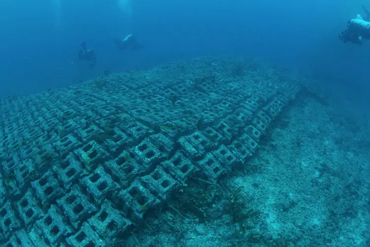
Bimini Road is an underwater rock formation located near the North Bimini island in the Bahamas. It is also called the Bimini Wall.

It is a long North East south west linear feature with a length of 0.8 km. It is composed of somewhat rectangular limestone blocks. Its origins are not clearly known. However, some theories claim that this feature could be a wall, a breakwater, a road, a pier or any other man-made structure.

It was discovered in 1968 by 3 divers. Carbon dating tells us that this feature was made by geological forces and not by humans. Still, some people claim that this could be the location of the lost city of Atlantis.

5) Steaming Black Sea


Phenomena of the Steaming Black Sea, more commonly known as sea smoke, frost smoke or steam fog is a natural phenomenon that is formed by the movement of very cold air over warm water.
In this, a light wind of very cold gets mixed with a shallow layer of saturated warm air which lies right above the warm water of the ocean. When the warm air can no longer hold so much of vapors the excess of it condenses out. This is similar to the production of steam over a hot bath.

This phenomenon appears to be turbulent. Sometimes it may even form spiraling columns. Sea smoke columns as high as 20 to 30 m in height have been observed. It is very common in the Arctic and Antarctic regions.

6) Julia Sound

Julia Sound was a weird noise which was recorded on 1st March 1999 by the National Oceanic and Atmospheric Administration, thought to be from somewhere around Antarctica. It was an eerie noise that sounded almost like someone cooling or whining. It lasted for about 15 seconds.

It was so loud that it could be heard from Antarctica till the Equatorial Pacific Ocean autonomous hydrophone array. The NOAA believes that the source of the sound could be a large iceberg that had run aground off. It is on the list of some of the spookiest and most mysterious sounds recorded in the ocean.

7) Baltic Sea Anomaly

Baltic Sea Anomaly
Baltic Sea Anomaly pic: Hauke Vagt

The Baltic Sea anomaly is nothing by the interpretations of an indistinct sonar image. It was accidentally discovered by the diving team in 2011. They claim to have found a 60 m thick circular entity about 90 m deep into the Baltic Sea.

The object seems to have unusual features and a non-natural origin. Some people believe that it is a sunken UFO. Scientist believes that the image is nothing but a geological formation. The divers also claim that attract that seems to be directed towards this object also exists. The length of the track is nearly 300 m.

Despite the many interpretations and media attention that this has received, scientists do not believe that the origin of this object could be extra-terrestrial. However, this still remains one of the most intriguing and unsolved mysteries of the oceans.

8) Green Flashes

Green Flashes
Green Flashes pic: Chris Mannerino

Green flashes are meteorological optical phenomena occurring in the oceans usually just before sunrise or after sunset. They can also occur over the top of clouds and mountains. A distinct green spot is visible for a few seconds above the upper room of the sun’s disc.

This may also occasionally resemble a green Ray shooting up from the point of sunrise or sunset. This phenomenon only takes place when the conditions are right. It happens because the earth’s atmosphere causes the light from the sun to separate into distinct colors. It can be called a natural prismatic effect.

Green classes are usually seen at unobstructed horizons, and hence usually take place over oceans. A green flash was photographed in color for the first time in 1960 from a Vatican Observatory.

 9) The convergence of Baltic and North Seas

Convergence of Baltic and North Seas

This is an oceanic phenomenon in which the Baltic Sea and the North Seas are visibly converging. However, there is no visible barrier present. The only barrier present is a chemical difference in salinity. It is known as a halocline. We can see the two different appearances of the seas.

We can say that the two seas do not mix because they have different rates of densities of water. The Baltic Sea mostly contains freshwater from a large land catch basin whereas the North Sea, which comes from the Danish Straits, is more saline in nature. This conversion takes place in the province of Skagen, Denmark.

Sometimes, surface mixing of the seas takes place because of regional temperature variations but in general, the seas are permanently separated. There is a lot of complicated chemistry involved in this phenomenon.

This is an unusual phenomenon and one of the most beautiful ones observed in oceans.

10) Underwater Crop Circles

Crop circles under the ocean, first spotted in 1995 off the southern coasts of Japan, were a matter of great intrigue and discussions for scientists. The locals termed these as mystery circles. These mystery circles actually remain a mystery until 2011.

The answer to this mystery is pufferfish. These species create elaborate circular designs in order to woo females. Scientists say that it is the quality of the circle that can help us determine of female’s mate choice.
Resorts team one observed 10 constructions going on by 4 to 8 male pufferfish. It took them about 7 to 9 days to build a circle. They use their fans to dig in the sandy bottoms. They also decorated the pics which shell and coral fragments.

These patterns also stored sand particles and post them towards the center of the circle which served as a real nest. When the mating is completed, and the eggs hatch, the nests are abandoned by the males and the process continues.

11) Sea Foam

Sea Foam
Sea Foam

Sea foam is a kind of foam created because of the agitation of seawater. It particularly happens when seawater contains higher concentrations of organic matter dissolved in it. This organic matter may come from sources such as algal blooms. Other organic matter maybe proteins, fats, pollutants, detergents, etc present in the water body. Sea form is also called as ocean foam, beach foam or spume.

If we collect this kind of seawater in a glass and shake it vigorously, we will observe small bubbles forming on the surface of the liquid.

Sea form is actually a normal phenomenon and not harmful in any way. However, in the case of algal decay on a grand scale, this sea foam thickens. This can have a harmful impact on human health as well as the environment.

12) Red Tides

Red tides are phenomena caused by algal blooms. In this, the algal blooms become so large in number that coastal waters get discolored by them. This may also cause a depletion of oxygen in the ocean waters other releases of toxins that are harmful to human health and the environment.

Some of the main factors that cause red tides are an increase in ocean surface temperatures, high nutrient contents, calm seas, sunny days after rain and winds, currents or ships which may carry these tides over long distances.

Some of the many countries affected by this phenomenon include Canada, England, Australia, France, India, Hong Kong, Italy, Japan, United States, Sweden, Spain etc.

Red tides are harmful because they release toxins in the ocean water. They may also trigger processes like biomagnification or bioaccumulation. They are harmful for aquatic life. give me also spread diseases in human beings such as food poisoning.

Currently, researchers are trying to develop an antidote to the toxins caused by red tides.

References:

  1. http://blogs.discovermagazine.com/d-brief/2013/08/15/underwater-crop-circles-mystery-solved/
  2. https://www.theactivetimes.com/travel/these-mysteries-seas-will-shock-you/slide-9
  3. https://en.wikipedia.org/wiki/Green_flash

Crop circles under the ocean


from WordPress https://www.maritimemanual.com/ocean-mysteries-and-phenomena/

What Are Rogue Waves?

Leading a successful voyage of a ship is a difficult and challenging affair especially in the middle of the oceans when the waters are most treacherous and perilous than ever. The ships could meet with any kind of obstacles like storms, icebergs for giant waves which main leads to capsizing. This article discusses one such hindrance called rogue waves.

A rogue wave is an enormous and unexpected surface wave. It is extremely dangerous even to large-sized ships. So much so that they are also called freak waves, monster waves, extreme waves, abnormal waves or episodic waves.

The waves are most dangerous because they can occur suddenly and without any warning. There is no way to predict their occurrence and the damage that they can cause may be enough to completely sink the ship. They mostly occur in the areas of the ocean where the waters are the deepest and may also be a result of a number of waves joining together. Their height is much larger than normal waves and it is most of the time, double. They can be as tall as 65 to even 100 feet as compared to the height of an average wave which is 39 feet.

Modern ships today are constructed to be able to tolerate a breaking wave of 15 metric tons per square meter. However, a rogue wave is capable of exerting a pressure of over a hundred metric tons per square meter. This figure is much larger than what the ship is prepared for. Hence the massive damage that they can cause is no surprise.

What causes Rogue waves?

These waves are not a result of earthquakes or tsunamis but are an open water phenomenon caused by winds, currents, solitons or other circumstances. These circumstances cause the wave to form much larger than the average height. The best explanation for this can be the occurrence of a phenomenon called constructive interference in which different waves traveling at different speeds pile up or combined together to form one giant wave.

Rogue waves can also be caused by the influences of strong currents. Currents can make the height of the waves increase and cause them to break. This is an acceptable explanation as rogue waves often occur in areas of the oceans which are known to experience strong currents. They are also common in the Bermuda Triangle and may be one of the explanations for the mysterious disappearances in the area.

Also read: What are water spouts?

How to predict Rogue Waves?

It has been almost impossible to predict the occurrence of rogue waves in the past years. However, modern technology has enabled us to somewhat predict their occurrence. One of the methods to do so is satellite tracking of wave formation. Because of this, it is possible for the crew of the ship to take necessary actions and try to prevent any casualties. Efforts are being made to construct ships that may be able to hold the damage and the pressure that these waves cause.

Rogue waves were considered to the non-existent and mythical in history because of the lack of evidence for their existence. Many people associated the causalities of the wave to be due to supernatural causes.

Today’s science and technology has allowed people to believe that they do exist. However, the precise reason for their occurrence is still not clear. Modern and sophisticated scientific methods have allowed us to somewhat foresee the waves and save lives. In the years to come, science may be able to help us to be immune to these waves to a much larger extent. Until then, ships can only hope to steer a course free from these monstrous waves or be informed about the approaching threat of rogue waves well in advance so as to save as many lives and prevent as much damage as possible.

References

https://oceanservice.noaa.gov/facts/roguewaves.html

Pic: https://ift.tt/3epOJUW


from WordPress https://www.maritimemanual.com/rogue-waves/

Tuesday, March 31, 2020

What Are TI Class Supertankers?

The TI class supertankers is a class of the four largest ships in the world by displacement, gross tonnage, and deadweight tonnage. They are owned by Tankers International L.L.C.

The TI in the name stands for the same (Tankers International). These were the first ultra-large crude carriers built in nearly the past three decades. They have contributed greatly to the transport of crude oil through waterways for many years. This class comprises four ships namely – TI Africa, TI Asia, TI Europe, and Tankers International. The original names of the ships at the time of their construction were Hellespont Metropolis, Hellespont Alhambra, Hellespont Tara, and Hellespont Fairfax respectively. They were built in South Korea by Daewoo Shipbuilding & Marine Engineering in Okpo in 2002 and 2003 for the Hellespont Group shipping company.

The four ships all together are also known as the fantastic four. They are all dual hull ships. They are safe for sharing oil without causing oil spills or major environmental hazards in case of accidents. Almost all of them have a speed of about 16.5 knots which is quite high. This enables the fast and time-efficient transport of cargo across countries.

The ships have ballast tanks and inert gas systems in order to reduce complications that may occur out of leakage of gases. The upper house of the ship is painted white in order to reflect the energy of the sun. Owing to all these features the hydrocarbon emissions from the ships have been considerably minimized. The ships also have the ability to travel through the Panama Canal as well as the Suez Canal.

Currently, three of the four ships have been converted into Floating, Storage and Offloading (FSO) vessels like the Knock Nevis before its scrapping, but all of them are still in use.
They have been in service for almost two decades now and are estimated to have a life of another 5 years.

Each of these four ships has been briefly described as follows.

1) TI Africa

TI Africa (Hellespont Metropolis)
TI Africa (Hellespont Metropolis) pic courtesy: Overseas Shipholding Group, Inc.

This is the second oldest shared among the four ultra-large crude carriers. It was awarded in January of 2000 and launched in September of the next year. It was initially named Hellespont Metropolis what was given its current name in 2004. It was purchased by the OSG group. It is a double hull ship that has a gross tonnage of about 234,000 tons. It was converted into a Floating, Storage and Offloading (FSO) vessel from a supertanker in 2010. It is still in service as of 2019.

2) TI Asia

TI Asia (Hellespont Alhambra)

TI Asia is the oldest ship among the four TI class supertankers. Ordered in January of 2001, it was launched in June of the following year. In 2010, it was converted into an FSO i.e. a Floating, Storage and Offloading vessel. It has a length of about 380 m and a beam of 68 meters. Its gross tonnage is 236,638 units. It was originally called Hellespont Alhambra but renamed as TI Asia in 2002. It was bought by the OSG Group like her sister, TI Africa.

3) TI Europe

TI Europe (Hellespont Tara)

The TI Europe was ordered in the year 2001 and launched in November 2002. It has a gross tonnage of about 234,000 tons and a speed of 16.5 knots. It has the capacity to carry more than 5 million liters of crude oil. Like its other sister ships (TI class supertankers), it has a length of 380 meters and a beam of 68 meters. It is owned by Euronav NV. It was initially named Hellespont Tara but was renamed in 2002. It was converted into a Floating, Storage and Offloading (FSO) vessel in 2017 and is still in service as of 2019. It currently comes under the French flag.

4) TI Oceania

TI Oceania (Hellespont Fairfax)
TI Oceania (Hellespont Fairfax) pic: The Hellespont Group

TI Oceania ship was ordered in 2001 and launched in the year 2002. It is almost exactly similar in dimensions to the rest of the TI class supertankers. It has a deadweight tonnage of nearly 400,000 tons and it has the capacity to carry more than 3 million barrels of oil. It is currently under the French flag but has also been under the Greek and Belgian flags at a point in its life. It is still successfully in service as a supertanker, unlike its other three sisters which have been converted into Floating, Storage and Offloading (FSO) vessels, as of 2019.

It was initially named Hellespont Fairfax at the time of construction. It was renamed as TI Oceania in 2004. Its currency name is Overseas Laura Lynn which is given to it in March 2015.


Videos


References:

https://tankersinternational.com/


from WordPress https://www.maritimemanual.com/ti-class-supertankers/

Monday, March 30, 2020

Maritime Manual Listed In Top 50 Shipping Blogs

Since its inception, we at Maritime Manual have strived hard to present the most up-to-date and authentic news about the shipping and cargo industry. In this short span, besides the readership and appreciation of our loyal readers, we have also received recognition from some of the best publications in the industry.

Recently, FeedSpot honored Maritime Manual by including it in the Top 50 Shipping Blogs list.

Maritime Manual thanks our readers and industry experts for their continued support and wishes!


from WordPress https://www.maritimemanual.com/maritime-manual-listed-in-top-50-shipping-blogs/

Saturday, March 28, 2020

Automatic Identification System

Modern-day ships are equipped with several modern equipment and safety measures to ensure a smooth and successful voyage. These new techniques have emerged and evolved from years and years of study, research and experimenting. One such system is the Automatic Identification System or AIS. This article discusses the meaning of this term, the purpose and uses of the system, its working, its limitations and the kind of role it plays on present-day vessels.

What is an Automatic Identification System?

An automatic identification system is a tracking system used by vessel traffic services. It displays the vessels lying in the proximity of another in order to avoid a collision. It uses transponders on ships. It is used for exchanging navigational information with the help of electrical signals.

What does AIS do?

As the term suggests, this system is automated and autonomous. AIS transponders are mandatory to be carried by all commercial vessels which have a gross tonnage of over 299 as well as all passenger vessels as per the International Maritime Organization since 2004.

AIS transponders consist of a global positioning system. The GPS collects the vessel position and location details. These details are automatically broadcasted via a transmitter at regular intervals of time. This information is received by base stations order vessels that are within range. These signals can be displayed on the computer all depicted on chart letters after processing. Some automatic identification systems also make the use of satellites for the same purpose.

Why is AIS used?

Automatic identification systems are quite often used as a surveillance tool especially in coastal areas where the authorities used to monitor the movement of ships through that area. The channels can also be used by the shore side authorities to convey information on tides and weather conditions to the incoming ships. Other information and instructions need to monitor ship containers in hazardous cargo for fishing vessels can also be provided with the help of AIS. It can also be used to find out about the availability of vessels in the proximity of an incident for SAR operations.

Another important use of the automatic identification system is the avoidance of collision. This is a part of providing navigational safety to the ships. Having an AIS is good for a ship as it allows to increase the situation awareness and decision making on the ship. It makes the crew of the ship aware of another vessel that may be in its vicinity. However, it is not advisable to solely rely on this system for avoidance of collision.

How does AIS work?

In the beginning, automatic identification systems were used terrestrially. In the system, the signal was sent from the boat to the land. It had a very small range of just about 20 miles and the signal began to get weaker as the boat moved further away.

Later on, satellite systems started getting adopted. Now the ships could send a signal to satellites and the satellites send them back to the land. This enables the authorities on land to know exactly where the ship is and at what time.

The automatic identification system consists of a transmitter, receivers and marine electronic communications link for sensor systems and display.

A GPS is normally used to derive the coordinates that are the position and timing of the vessel.

One channel is sufficient for communication. Still, the most station transmits and receive more than one radio channel so as to avoid interference and communication losses with ships.

Every 6 minutes, static information like name and call sign, length and beam, type of ship, location of antenna, MMSI no., IMO no. etc. are transmitted. dynamic information transmitted includes the position of the ship, the position time stamp and the course over ground. Other than this information transmitted at regular intervals of time includes the draught of the ship, destination, the type of cargo being transported, routine plan, etc.

The main purpose behind fitting AIS on ships is for their identification and navigational marks. In regions like the Panama Canal, the automatic identification system is also used to provide information about rain, wind and other weather conditions.

Though it was initially started as a method of controlling marine traffic and avoiding collisions, it is an undeniable fact that its capabilities are applicable to a wider spectrum. Nowadays these systems are used by port authorities, ship owners, managers, builders, ship agents, brokers, researchers, data analysts, charterers, hotel, and tour operators, search and rescue teams, operators, pilots, harbormasters, flag administrators, classification societies, passengers, sailors, vessel crew, coast guards, border patrol, marine enthusiasts, radio amateurs, environmental protection agents, etc.

AIS Types

Class A

Class A AIS  is included for all SOLAS vessels of 300 gross tonnage and upwards engaged on international voyages,  vessels of 500 gross tonnage and upwards not engaged on international voyages and passenger ships irrespective of size.

Class B

Class B AIS is intended for non-SOLAS vessels. These include domestic commercial vessels such as pleasure crafts. AIS Class B units provide less functionality than Class A units but they operate and communicate with AIS Class A units and other types of AIS units.

What Information is transmitted by an AIS?

An AIS can send 2 types of information – Dynamic or Static information.

1) Dynamic information refers to the data transmitted every 2-10 seconds depending on the vessel’s speed and course while underway or every 6 minutes if the vessel with Class A transponder is at anchor.

  • MMSI number: unique identification number with nine digits
  • AIS Navigational Status: “0=under way using engine”, “1=at anchor”, “2=not under command”, “5=moored”, “8=under way sailing”
  • Rate of Turn: right or left (0 – 720 degrees per minute)
  • Speed over Ground: from 0 to 102 knots (189 km/h) with 0.1-knot resolution (0.19 km/h)
  • Position: (latitude&longitude – up to 0.0001 minutes accuracy)
  • Course over Ground: relative to true north to 0.1°
  • Heading: 0 – 359 degrees
  • UTC seconds: the seconds’ field of the UTC time when these vessels’ data was generated

2) Static & Voyage related information is provided by the subject vessel’s crew and is transmitted every 6 minutes regardless of the vessel’s movement status

  • International Maritime Organisation number (IMO number): a unique code associated with the hull which remains the same throughout a ship’s lifetime even if it changes owners.
  • Call Sign: international radio call sign assigned by the vessel’s country’s licensing authorities
  • Name: Name of the vessel. It can have a maximum of 20 characters
  • Type: It consists of two digits. While the first digit indicates the vessel’s category and the second digit provides tells the type of cargo.
  • Dimensions: indicates the size of the vessel to the nearest meter
  • Location of the positioning system’s antenna on board the vessel: distance from bow, stern, port and starboard sides in meters
  • Type of positioning system: GPS, DGPS, Loran-C, GLONASS, etc.
  • Draught: 0.1 – 25.5 meters
  • Destination:  upto 20 characters
  • ETA (Estimated Time of Arrival) at destination: UTC month/date hours:minutes

Where is AIS Used?

AIS used by a diverse set of professionals such as :

  • Port Authorities and Harbor Masters
  • Tug Operators and Pilots
  • Coast Guard and Border Patrol
  • Ship Owners, and Builders
  • Ship Agents, Brokers, and Charterers
  • Researchers and Data Analysts
  • Naval Search and Rescue teams
  • Flag administrators and Classification Societies
  • Vessel crews and family members
  • Hotels and Tour operators
  • Passengers or recreational sailors
  • Environmental Protection agents
  • Maritime Enthusiasts and Radio-amateurs

Limitations of AIS

AIS has proved to be an efficient and important part of modern ships. However much like any other implementation in the world, the AIS has its limitations.

First of all, the accuracy of the information which is received depends on the information transmitted and is only as good as the latter. Even today not all ships are equipped with an automatic information system. one should also be aware that an automatic information system can be switched off by any vessel at any time. Due to this, the ship might negate any information that it has previously received. Accuracy of the positions that is the latitude and longitude received by the GPS is also not certain. There is only so much that can be done about precision.

Finally, one must understand that the automatic information system is one of the best tools ever to be introduced in the marine industry. It forms an important part of the navigational equipment on board modern vessels. As useful as it is for navigation and accident prevention, it should be realized that the system is merely present for the purpose of assisting the crew of the ship and it cannot completely replace human beings or human resources.


from WordPress https://www.maritimemanual.com/automatic-identification-system-ais/

Friday, March 20, 2020

Top 12 Most Famous Sunken Ships

Ships have been a part of human history since time immemorial. Over the centuries, humans have managed to design different types of ships for serving different purposes such as transport, rescue, fishing, leisure, etc. Even today, ships are an indispensable part of human life.

Thousands of ships set sail every day and several are under construction. All ships serve humans throughout their life while some meet an untimely and unfortunate end by capsizing. Sunken ships have led to losses of millions of lives and artifacts in history, some of which remain famous to date. This article lists some of the most amazing sunken ships in the world.

1) The HMHS Britannic

The HMHS Britannic
The HMHS Britannic

The HMHS Britannic was a sister ship of the infamous RMS Titanic. It was constructed by the same company i.e. the White Star Line after the sinking of Titanic. Keeping in mind the previous tragedy, the HMHS Britannic was built with more safety measures such as a greater number of lifeboats and a reinforced hull around the parts vulnerable to icebergs. It was much larger than the Titanic. It could have been a cruise ship but was requisitioned by the government as a hospital ship as the world war broke out. After about a year of service, it was brought down by the enemy fire. Luckily, most of its 1000 passengers survived. It is one of the most famous sunken ships in naval history.

2) MV Rozi

MV Rozi
MV Rozi

MV Rozi or Tugboat Rozi is a ship that was deliberately sunk after being decommissioned, as an artificial reef in Malta. Divers are allowed to go scuba diving in the area. In fact, it has become one of the most popular scuba diving destinations in Malta. The ship has been under the ownership of Captain Morgan Cruises since 1992.

3) Giannis D

Giannis D
Giannis D

Giannis D was a cargo ship built in Japan in 1969. In 1983, the ship was on a voyage from Yugoslavia to Yemen. The ship drifted west of the set course in the Straits of Gubal and capsized that night and broke into half. Today, it is used as a diving site.

4) Frigate 356

Frigate 356
Frigate 356

The ship was one of the last of the Soviet combat vessels built towards the end of the cold war during the early 1980s. The use of this vessel was discontinued following the fall of the Soviet Union. It is more than 300 feet long and currently can be found at the bottom of the waters of Cayman Bay. The marvel here is that the shape has not corroded or oxidized even when it sank more than 20 years ago because it was mostly made out of aluminum.

5) Sweepstakes

Sweepstakes Ship
Sweepstakes Ship pic courtesy: https://www.flickr.com/photos/44124370018@N01/48484766072

This was a vessel built-in 1867 in Ontario. It sank at the big tub harbor in 1885. It could not be repaired at it had suffered serious damage. However, the coal that it was shipping was retrieved. The hull of the ship is still intact and rests in the water at the depth of 20 feet a few yards away from Big Tub Harbor.

6) RMS Lusitania

RMS Lusitania
RMS Lusitania

The RMS Lusitania was a British ship that was used to transport war munitions during the first world war under the group that it wouldn’t be attacked by the Germans as it was a non-military ship. It was briefly the largest ship in the world. It was sunk by a German U-boat in 1915. The wreck of the ship can be found near the lighthouse at Kinsale.

7) USS Arizona

USS Arizona
USS Arizona

When we talk about sunken ships, how can we forgot this mighty warrior? USS Arizona is one of the most famous wartime casualties in the world. It came into service in 1916 and was struck in 1942. It sank during the attack on Pearl Harbour. It is one of the most famous shipwrecks in the world. Memorial to pay tribute to the Navy men who gave the lives for the country has been built on top of this wreck. It is one of the sunken ships in Pearl Harbor.

8) P29

P29 Maltese Patrol Boat

P29 was a petrol boat from Malta. It was resold to the country after being abandoned by the Volksmarine before the reunification of Germany. This is another example of a boat that was sunk for the purpose of recreational diving. It was scuttled in 2007.

9) Whydah Gally

Whydah Gally
Whydah Gally

This was a pirate ship that belonged to ‘Black Sam’ Bellamy. He was one of the most successful pirates in history. The amount of treasures that he collected in his life from ships would be was nearly 120 million dollars today. He and his ship met an end when his ship was struck by a huge storm and sank resulting in the death of most of his crew and himself. Most office Treasure also sank with the ship. The wreck was discovered 260 years later and much of the treasure has been recovered.

Also read: Top 10 Historic Ships

10) Queen Anne’s Revenge

The Queen Anne’s Revenge
Queen Anne’s Revenge

Another pirate ship, Queen Anne’s Revenge was one of the most fearsome ships to ever sail the seas. It was used as a flagship by the infamous pirate, Edward Teach, commonly known as Blackbeard. He used the ship for less than a year in 1717. The wreck of the ship was discovered in 1996. However, it took a long time for it to be identified as Queen Anne’s Revenge. Thousands of valuable items and artifacts were recovered.

11) USS Utah

USS Utah
USS Utah

The USS Utah is yet another example of a second world war causality. It also sank during the attack on Pearl Harbour in 1941. It was commissioned in 1911. The wreck of the ship remain in the Pearl Harbour. A memorial dedicated to the men who were killed in the attack has been placed at the wreck.

12) HMS Prince Albert

HMS Prince Albert
HMS Prince Albert

This ship was once used to do transport people from Nicaragua to Roatan. After it was decommissioned, it was purchased by a local resort owner. It was deliberately sunk to be turned into a popular recreational diving area.


from WordPress https://www.maritimemanual.com/famous-sunken-ships/

Tuesday, March 3, 2020

How To Make Cargo Operation On Oil Tankers Safer?

Emergencies are not uncommon in the marine world, especially during a voyage. It is even more difficult to transport oil as oil tankers may be vulnerable to challenges like leakage, fire emergencies or threats from pirates.

Each and every person involved in the operation of a ship is trained to act in an emergency situation. There are some necessary precautions and safety measures that can help a ship’s management to ensure a risk-free and smooth sail.

How To Make Cargo Operation On Oil Tankers Safer?

Following are some of those safety measures which can make the cargo handling operations safe.

1) Close Accommodation Openings

The accommodation area of a ship is the living space which contains all the cabins for the ship’s crew, meeting rooms, lockers, mushrooms, provision stores, recreational rooms, etc. During a cargo operation, it should be ensured that all the openings to this area are closed. This helps to prevent cargo vapors from ingressing or entering. This measure needs to be taken for the sake of safety despite the discomfort that the crew might face because of the temperature and humidity.

2) Keep Vents Open

All cargo tank vents and high-velocity vent valves should be operational during the handling process. All P/V valves must also be checked during ballast watches for safe and proper operation.

3) Closing Sighting and Ullage Ports

An ullage tank is a tank that is almost full. On an oil tanker, all ullage ports must be closed securely and not opened until there is a requirement. No sampling, sound or auditing of tanks must be in progress while connecting or disconnecting the burning cable to the ship.

4) Shut Down Ballast Tanks

All segregated ballast tanks should be closed. Cargo leaks from the cargo tanks into permanent ballast tanks this can create a serious pollution problem. Ingress of water from the ballast tanks into the cargo spaces should also be checked on a daily basis.

5) Short Natural Ventilation

If need be, any kind of ventilation must be shut off or isolated from the direction of the cargo vapor flow.

6) Shut Tank Lids

No tank lids on the entire vessel should be left open. It should be ensured that all cargo tank hatches, ports or access openings are closed tightly. In this manner, the escape of oil and other hydrocarbon vapors can be prevented.

7) Strainer Cover, Drain Plug and Inspection Plates

A strainer is a simple device that is installed to hold large foreign objects from causing damage or blockage. It should be ensured that the strainer cover, inspection plate and drain plug located in the pump room are in proper positions.

8) Check Pump Room

A pump room is that area of the ship which contains the largest concentration of pipelines. The pump room of a ship should be positively checked at regular intervals of time especially during cargo handling.

9) Gas Freeing Operation

During a gas freeing operation or tank washing, it should be ensured that all the washing covers are removed. At all the other times, they should be closed. Only the people who are directly involved in the operations should be allowed on the main deck. Also, everybody involved in the operation should be dressed appropriately and observe anti-static precautions.

10) Checking High-Pressure Alarm

During the loading operation, the high-pressure alarm of the cargo tanks should be checked properly.

11) Shut AC If Required

Sometimes the air conditioning systems’ intake air could draw cargo vapors. In such a case, the AC system should be stopped. Hence, the accommodation area will find its ports shut.

12) Cargo Hoses and Flange Connections

A cargo hose is used to ship to shore products like chemicals. A flange is a rim that is installed for increasing the strength of another object. Cargo hoses in flanges should always be checked thoroughly before use. All the courses should also be handled properly. They should be lifted and not dragged on the deck. Cargo hoses in flanges should also be supported at various points in order to avoid twisting. They must also be adjusted according to the draught of the shape of the cargo operation proceeds.

In the same manner, all flanges must also be properly tightened using bolts. One should always be careful while removing a flange from any section of the pipeline in order to ensure that it does not contain oil at pressure and is made up of approved metal like steel.

13) Check Limit of Elevation

A metal cargo arm is designed in such a way that it can operate under various elevations arising because of the tidal effects. The limit of elevation of metal cargo arms must also be examined properly. This involves a comparison with the ship’s data. The cargo operation can only be improved in all the criteria for this are met.

14) Isolate Window AC Unit

If the time comes, any kind of window AC unit present on the ship needs to be shut down or isolated.

15) Check Gland Condition of Pumps

It should be ensured that the gland conditions of all the cargo pumps situated in the pump room are thoroughly checked and examined.

16) Check Alarms and Trips

It is to be ensured that all alarms and trips are working properly before any cargo operation begins.

17) Handling the Arm

The metal arm is acquitted with a parking lock. This parking lock should not be tampered with or removed unless and until the metal arm is empty. If it is opened before, it can lead to an oil spill. Also, if the arm has any ice on it, it must be removed immediately before opening the lock or else it could cause an imbalance.

18) Mooring Ropes

One should always keep an eye on the mooring ropes with which the arm is connected for operation. They should always be monitored, and the operation should be stopped immediately if there is excessive drifting.

19) Earthing

This is one of the most important precautions to be taken. Pipeline flow may electrostatically charge the static accumulator oil. Hence, pipeline bonding is mandatory so that electrostatic charge accumulation can be prevented. So, the pipelines should be bonded to each other and to the structure of the ship. The structure of a ship is finally naturally earthed to the sea through the hull.

20) Check Emergency Release

Emergency releases should be checked in advance and the draining arrangements should be ready so that as much oil as possible can be drained out if there is a situation of an oil spill.

21) Lighting

During night time, it must be ensured that the cargo station and pump rooms are provided with sufficient light.

22) Weather

The master of the ship and the terminal in charge should always keep an eye on the weather conditions at sea at all times. In case of rough weather like lightning or storms, the ship cargo operation should immediately be stopped.

23) Keep Equipment Ready

All sorts of safety equipment such as oil spill fighting equipment, firefighting equipment as well as personal protective equipment, gas detection equipment, etc. must be ready at all times to ensure maximum safety.

24) Crew

Finally, the crew of the ship should be well aware of their duties and must be well trained about how to react during an emergency situation at regular intervals of time.

Also read: 15 Common Oil Cleanup Methods At Sea

References:

  1. http://www.imo.org/en/OurWork/Safety/Regulations/Pages/OilTankers.aspx


from WordPress https://www.maritimemanual.com/how-to-make-cargo-operation-on-oil-tankers-safer/

15 Deepest Parts Of The Ocean

The earth is known as the ‘blue planet’ because of its blue appearance from space. This blue color obviously comes from the oceans on earth ...